Analyze data from RunKeeper.
Connect to your RunKeeper account:
In[68]:=
runkeeper=ServiceConnect["RunKeeper"]
Out[68]=
ServiceObject
Import the distances of your recent activities:
In[75]:=
distances=Lookup[runkeeper["FitnessActivities"],"TotalDistance"]
Create a table of statistics:
In[84]:=
stats={Mean,Median,Max,Min,StandardDeviation};table=Grid[{stats,Through[stats@distances]}]
Out[85]=
Mean | Median | Max | Min | StandardDeviation |
1489.8m | 1403.02m | 3218.69m | 4.7485m | 740.408m |
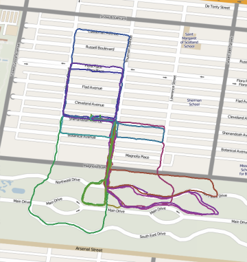
Use the statistics as the label on a map of your routes:
In[86]:=
Labeled[Show[runkeeper["PathsMap"],ImageSize400],table]
Out[86]=
|